2025
Frazier, A., Nelson, T., Kedron, P., Shook, E., Dodge, S., Murray, A., Goodchild, M., Battersby, S., Blanford, J. I., Claramunt, C., Holler, J., Koylu, C., Lee, A., Manson, S., Salap-Ayca, S., Wilson, J., Zhao, B., Bennett, L., Cabrera-Arnau, C., Franklin, R.,
McKenzie, G. , Miller, H., Oshan, T., Rey, S., Rowe, F., Spielman, S., Xu, W.
Reflecting on the role of GIScience Education in an age of disruptions.
Transactions in GIS. 29(2). e70048. Wiley. [
10.1111/tgis.70048]
2025
2024
2024
Nelson, T., Frazier, A., Kedron, P., Dodge, S., Zhao, B., Goodchild, M., Murray, A., Battersby, S., Bennett, L., Blanford, J. I., Cabrera-Arnau, C., Claramunt, C., Franklin, R., Holler, J., Koylu, C., Lee, A., Manson, S.,
McKenzie, G. , Miller, H., Oshan, T., Rey, S., Rowe, F., Salap-Ayca, S., Shook, E., Spielman, S., Xu, W., Wilson, J.
A research agenda for GIScience in a time of disruptions.
International journal of geographical information science. Taylor & Francis. pp. 1-24. [
10.1080/13658816.2024.2405191]
2024
2024
2023
2022
Psyllidis, A., Gao, S., Hu, Y., Kim, E-K.,
McKenzie, G., Purves, R., Yuan, M., Andris, C.
Points of Interest (POI): a commentary on the state of the art, challenges, and prospects for the future.
Computational Urban Science. Springer. [
10.1007/s43762-022-00047-w]
2022
2022
2021
2021
2020
2020
2020
2020
2019
2019
2019
2018
2018
2018
2018
2018
2017
2017
2017
Gao, S., Janowicz, K., Montello, D., Hu, Y., Yang, J.,
McKenzie, G., Ju, Y., Gong, Li., Adams, B., Yan, B.
A Data-Synthesis-Driven Method for Detecting and Extracting Vague Cognitive Regions International Journal of Geographical Information Science. 31(6) 1245-1271. Taylor & Francis [
10.1080/13658816.2016.1273357]
2016
2016
2016
2016
2015
2015
2015
McKenzie, G., Janowicz, K., Gao, S., Yang, J-A., Hu, Y.
POI Pulse: A multi-granual, semantic signatures-based information observatory for the interactive visualization of big geosocial data.
Cartographica: The International Journal for Geographic Information and Geovisualization, 50(2) 71-85. The University of Toronto Press [
10.3138/cart.50.2.2662]
2014
2025
2023
2023
2023
Shi, M., Currier, K., Liu, Z., Janowicz, K., Wiedemann, J.,
McKenzie, G., Graser, A., Zhu, R., Mai, G.
Thinking Geographically about AI Sustainability.
Proceedings of the 26th AGILE Conference on Geographic Information Science (AGILE '23). (Delft, the Netherlands; June 13-16, 2023).
2023
2022
2022
2022
2021
2021
2019
2018
2018
McKenzie, G., Janowicz, K.
OpenPOI: An Open Place of Interest Platform.
Proceedings of the 10th International Conference on Geographic Information Science (GIScience '18'). Short Paper. (August 28-31, Melbourne, Australia). Dagstuhl
2017
Sinha, G., Arundel, S., Stewart, K., Mark, D., Hahmann, T., Romero, B., Sorokine, A., Usery, L.,
McKenzie, G.
A reference landform ontology for automated delineation of depression landforms from DEMs.
Conference on Spatial Information Theory (poster session). (September 4-8, L'Aquila, Italy) [
Poster]
2017
2017
2017
2016
2015
2015
2014
2014
2014
Gao, S., Yang, J-A., Yan, B., Hu., Y., Janowicz, J.,
McKenzie, G. Detecting Origin-Destination Mobility Flows From Geotagged Tweets in Greater Los Angeles Area.
Extended Abstracts of the Eighth International Conference on Geographic Information Science (GIScience 2014) Vienna, Austria
2013
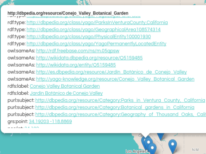
McKenzie, G., Janowicz, K., Hu, Y., Sengupta, K., Hitzler, P.
Linked Scientometrics: Designing Interactive Scientometrics with Linked Data and Semantic Web Reasoning.
The 12th International Semantic Web Conference (ISWC '13) (Demonstration Paper) Sydney, Australia [
Video]
2012
2012
Hu, Y., Li, W., Janowicz, K., Deutsch, K.,
McKenzie, G., Goulias, K.
Using spatial-temporal signatures to infer human activities from personal trajectories on location-enabled mobile devices. Extended Abstracts of the Seventh International Conference on Geographic Information Science (GIScience 2012), Columbus, OH.
2012
2011